 Goemkarponn Desk
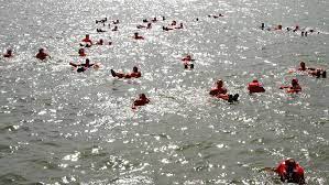
PANAJI: Government of Goa has notified the Local Contingency Plan (LCP) for Mass Rescue Operations (MRO) at Sea for Goa.
The notification will come into force from today. The objective of the plan is to prepare a comprehensive contingency plan for large scale rescue capabilities for saving lives at sea.
The State of Goa has about 555 km of Inland Waterways out of which only 255 km are navigable through the Rivers Mandovi, Zuari and their tributaries.
Out of their total length the better part is being used by the mining and export Industry for transportation of Iron ore to the port of Mormugao and Panaji outer anchorage, from the loading points in the hinterlands.
The coast line of Goa is nearly 108 kilometres with the Terekhol River separating Goa and Maharashtra. In the south Galjibag river is the last river in the Canacona Taluka
Panaji is anchorage port which can handle vessels up to LOA 280m. The principal exports are cotton, salt and seeds; the main imports are piece goods, kerosene, pig iron, coal, lime, iron ore, etc. Traffic figures: Approximately 210 vessels visit the port annually. Load line zone: Arabian Sea Seasonal Tropical Area, Tropical Sep 1 to May 31, Summer Jun 1 to Aug 31. Max size: Anchorage: Max LOA 280m, beam 46m, draught 17.0m, 155,474DWT
The Captain of Ports Department is headed by the Captain of Ports with its headquarters at Panaji, Goa. He is the overall controlling authority of the department. Besides there are sub offices at Mormugao-Dy. Captain of Ports, at Britona-Marine Slipway & Maritime School, at Chapora, Betul and Talpona-Marine Secretary:


