New Delhi: Farmers in Punjab and Haryana are increasingly finding ways to avoid satellite detection while burning crop residue, exposing major gaps in India’s existing system for monitoring stubble fires.
The challenge has drawn comparisons with India’s 1998 Pokhran nuclear tests, when scientists led by Dr APJ Abdul Kalam successfully concealed preparations for the country’s nuclear tests from sophisticated American surveillance satellites.
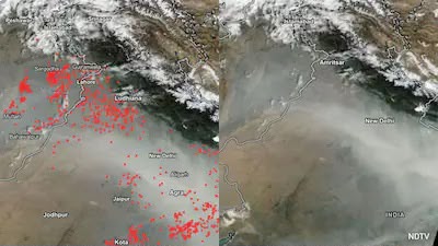
Nearly three decades later, farmers appear to be exploiting a similar weakness in satellite surveillance. Since satellites observe specific locations only during scheduled periods, fires started outside these observation windows can escape detection.
This growing concern has prompted the International Forum for Environment, Sustainability and Technology (iFOREST) to introduce Fire Watch, a new satellite monitoring platform designed to provide a more comprehensive picture of agricultural burning.
The number of officially detected farm fires has dropped significantly, from nearly 80,000 incidents in 2021 to around 6,000 in 2025. Government measures, including penalties, enforcement drives, machinery subsidies and awareness campaigns, have contributed to the decline. However, experts believe changing burning patterns and satellite observation gaps may also explain part of the reduction.
Traditional monitoring mainly depends on four polar orbiting satellites operated by NASA and other agencies. These satellites provide fire alerts when they pass over specific locations, leaving considerable gaps between observations.
Fire Watch attempts to overcome this limitation by combining data from multiple satellite systems. It uses MODIS and VIIRS for detecting active fires, along with Meteosat-8 and Meteosat-9, which can observe the same region approximately every 15 minutes.
The platform also incorporates Sentinel-2 imagery to compare agricultural land before and after the burning season, helping estimate the actual area affected by fires.
A 2026 Parliamentary Standing Committee has also highlighted India’s dependence on foreign satellite systems for environmental monitoring and recommended developing geostationary satellites capable of continuous fire surveillance.
India’s EOS-05, also known as GISAT-1A, offers significant potential, with the ability to image selected regions every five minutes. However, the satellite remains under in-orbit testing, and its operational access involves national security considerations.
Meanwhile, scientists point out that even when farmers manage to escape direct satellite detection, the burnt remains of agricultural fields can still be identified through high-resolution satellite imagery.
India’s National Remote Sensing Centre regularly analyses these burnt areas and shares assessments with the Commission for Air Quality Management.
The growing use of satellite technology has therefore turned stubble burning surveillance into a continuing challenge, where detecting the actual fires is only one part of the battle.